Raisen District
Raisen |
About: |
|
Raisen is a town and a municipality in Raisen district in the Indian state of Madhya Pradesh. It is the administrative headquarters of Raisen District. Raisen takes its name from the massive fort at the top of a hill. The town is located at the foot. The name is probably a corruption of Rajavasini or Rajasayan—the royal residence. |
Location info: |
| Raisen District lies in the central part of Madhya Pradesh. The District is situated between the latitude 22 47' and 23 33' north and the longitude 7721' and 78 49' east. It is bounded in the west by Sehore district, in the north by Vidisha district, in the ease and south-east by Sagar district, in the south-east by Narsimhapur district, and in the south by Hoshangabad and Sehore district. The total area of the District is 8,395 Sq. Km., which contains the 1.93 % of the State's area. |
Climate/Weather: |
|
Climate condition in Raisen district is normal. During the summer season the mercury raises upto 420 C and during the winter, the climate is cold and the temperature is around 50 C. The district is getting about 1200 MM average rainfall in normal condition. |
History of Shahdol |
|
Raisen with a strong fort was an important centre of administration from the period of its foundation from Hindu times. In the fifteenth this fort was ruled by the Sultans of Mandu, from whom it passed to the Rajputs. In 1543 Shershah Suri captured from Puranmal. In Akbar's time Raisen was the headquarter of a Sarkar in the Subah of Ujjain in Malwa. Fiaz Mohammad Khan, the third Nawab of Bhopal State occupied it in about 1760, later got himself recognized as Faujder of Raisen by Emperor Alamgir II. During the Mugal period Khamkhera was the headquarter of the area noe falls in Gairatganj Tehsil. It receives its present name during the same Mugal rule. Shahpur was the headquarter of the Pargana. Later on it was shifted to Sagoni, which falls in Begamganj Tehsil. Raisen District takes its name from massive Fort. This fort is build on a sandstone hill, at the foot of which settles the town. The name is probably a corruption of Rajavasini or Rajasayan, the royal residence. After Bhopal State became a part 'C' State of the Union of India, the present district came into existence on 5th May, 1950, with headquarter at Raisen. It was decided to retain only seven Tehsils in the district. |
Educational Institutions in Raisen: |
|
Vns Group Of Educational Institutes Vies Alchem Institute For Iit-Jee Pathfinder Education Services Khare Academy Jagdamba Tools |
Langauges: |
| Hindi and other regional languages |
Culture: |
|
Raisen district covers seven Development Blocks and Tehsils. Three Municipalities, Six Town Panchayats, 501 village Panchayats, Seven Janpath Panchayats and One District (Jila) Panchayats are working in the district. District Administrative offices are located in district head quarter Raisen. Rainwater is the main source for carrying out agricultural activities in the district. All blocks are getting average rainfall in normal condition.Different type of soils found in different parts of the district. However, light Black soils, light Red & thick red soils with core sand are the predominant soil types available in the district. There is no perennial river in the district. The Betwa River originates from this district. But the benefit is not available for the district. Narmada River flows in the district and irrigation facilities available in Bareli Tehsil. Bina, Halali, Neon, Basna, khand, Tadni, Bawas and Dhaman are other small rivers flows in the district. In summer Season, these rivers become dry. This is one of the main drawbacks for the fast development of the district. All Development Blocks of the district are having a considerable area under forest. Total forest area in the district is about 1, 16, 424 hectare out of which about 105614.400 hectare forestland is in Goherganj tehsil and followed by Silvani tehsil which is about 25.5 thousand hectares. 62.26% of the forest area falls under reserved forest and 35.82% declared as protected forest area and the femaining 1.91% is scheduld forest area. The district is having enough forest wealth, wherein the production of Building woods, Firewood and valuable medicinal plants are produced. Sects of population depend on the forest for their livelihood. More industries can come up on forest based products, which will help to improve the employment generation in the rural areas substantially. About 70% of the working population of 26% of the total population totally engaged in agricultural activities. More pressure on land and agricultural creates more disguised and seasonal unemployment. As a result of unemployment and under employment, per capita income of the people are low and the standard of living remains unchanged for several decades. The occupational pattern should be changed and the people should come forward to involve in other income earning activities. Family industries and other traditional industries are vanishing in rural areas, that is also one the reasons for increasing unemployment. Agriculture is the main occupation of the district. About 70% of the working population are engaged in crop growing activities. Agricultural activities are carried out in two seasons namely rainy season (Kharif) and winter seasons(Rab). It has been observed that the tools and implements used by the farmers of the district are comparatively few in numbers, smaller in size, crude and antiquated in character. The ploughing is done iron-shod wooden plough with the help of pair of Bullocks/Buffaloes and Tractors, This type of indigenous plough does not penetrate deeply into the soil and widely enough. Use of chemical fertilisers is widely reported in the district. |
How to reach Raisen? |
|
Nearest Railway Station: nearest railway station is the Sagar Railway Station. |
|
Nearest Airport: Bhopal is the nearest airport, which is only about 45 km |
|
Road Transport: Raisen bus station |
Tourist Attraction of Raisen: |
|
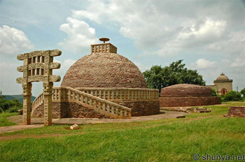
The most visited place in Raisen is the Shrine of Hazrat Peer Fatehullah Shah Baba who was a well know muslim saint. People have a strong belief that ones desires are fulfilled if asked to God via Hazrat Peer Fatehullah Shah Baba. Visitors are also attracted to the sprawling Raisen fort which includes a few temples, palaces, a large water reservoir and some 40 wells. In the vicinity of the fort there are also several caves with ancient wall paintings. Sanchi Located on the foot of a hill-- Sanchi is just 46 kms Bhopal. It is more of a village than a town. Sanchi is a religious place with historical and Archaeological significance. Sanchi is a site for the numerous stupas which were built on a hill top. The place is related to Buddhism but not directly to the life of Buddha. It is more related to Ashoka than to Buddha. Ashoka built the first stupa and put up many pillars here. The crown of famous Ashoka pillars, with four lions standing back to back, has been adopted as the national emblem of India. Sanchi adopted Buddhism which replaced the prominent Hinduism. But time took its toll and slowly both the stupas and the place were forgotten. In 1818 Sanchi was rediscovered and it was found that the marvelous pieces of structure were not in good shape. Gradually historical and the religious significance of the place was recognise d. Restoration work of the stupas started in 1881 and finally between 1912 and 1919 these were carefully repaired and restored. It was accepted that the structure at Sanchi are the most organised construction which went into the engineering of temples in the medieval period. The carvings here are done with the precision of Jewellers. Despite the damage and restoration work done Sanchi is the most evocative and attractive Buddhist site in India. Sanchi is primarily a place of Stupas and pillars but the gorgeous gateways add grace to the place. These gateways are beautifully carved and carry scenes from the life of Buddha or Ashoka. These gateways are the finest specimens of early classical art, which formed the seed bed of entire vocabulary of later Indian art. The images carved on the pillars and the stupas tell moving story of the incidents form the life of Buddha. SIGHTSEEING: STUPAS: Sanchi has been famous for the Stupas which were built on the top of a hill. The purpose of these stupas was mostly religious. The most likely use of the stupas has been said to keep the relics. Some of these stupas have been found containing relics of disciples of Buddha. The stupas date as early as the 3rd century and are built in brick made of stone. Though most of the stupas are in ruins now three remain intact and are of great archaeological value. The designs and the carvings on the walls and gates of these stupas spell a heavenly grace and are very tastefully done. The Four Gate Ways - The Four gateways constructed in 35 BC are the best from of Buddhist expression one can find any where in the world. Gateways or Torans as they are called are covered with explicit carving which depict scenes from the life Buddha and Jatakas, the stories relating to Buddha and his earlier births. At this stage Buddha was not represented directly but symbols were used to portray him-- The lotus represents his birth, the tree his enlightenment, the wheel, derived from the title of his first sermon, the footprints and throw symbolising his presence. The carvings on the Torans are done with inspired imagery which in harmony with the surrounding figures balance the solidity of massive stupas. The Ashoka Pillar - The Ashoka pillars is one many pillars which are scattered in the area some of these are in broken and some in shape. The Ashoka pillar is on the southern entrance. Today here only the shaft stands and the crown is kept in the museum. The crown is the famous four lions which stand back to back. This figure was adopted as the national Emblem of India. The Ashoka pillars are an excellent example of he Greco-Buddhist style and is known for the aesthetic proportions and the exquisite structural balance. The Buddhist Vihara - The earlier monasteries were made from wood which was exquisitely carved and tastefully decorated. The present monasteries are not even the shadow of what they were in the past. A few kms from Sanchi are the relics of the Satdhara Stupa. The relics are kept in glass casket which is placed on the inner sanctum of the modern monastery. The Great Bowl - Sanchi had a huge bowl carved out of single rock. Grain was stored in this bowl and it was distributed among the monks in Sanchi. The Gupta Temple - This temple is now in ruins. But what ever is left tells a saga of greatness and a temple which had no match during its times. The temple was built in 5 the century and is an excellent example of ancient temple architecture in India. The Museum - The archaeological survey of India maintains a museum which house many items which were discovered during the excavation of Sanchi area. Most prized possession of the museum is the lion crown from Ashoka pillar. The museum has a sizeable collection of utensils and other items used by the monks who lived here. Bhojpur Founded by the legendary Parmar king of Dhar, Raja Bhoj (1010-53), and named after him, Bhojpur, 28 km from Bhopal, is renowned for the remains of its magnificent Shiva Temple and Cyclopean dam. The temple, which has earned the nomenclature of the Somnath of the East, is known as the Bhojeshwar Temple. In plan a simple square, with an exterior dimension of 66 feet, it is devoid of the re-entrant angles usual in such buildings. The richly carved dome, though incomplete, has a magnificent, soaring strength of line and is supported by four pillars. These, like the dome, have been conceived on a massive scale, yet retain a remarkable elegance because of their Bhojeshwar Temple tapering form. Divided into three sections, the lowest is an octagon with facets of 2.12 feet, from which springs a 24-faced section. Richly carved above, the doorway is plain below, throwing into sharp relief the two exquisitely sculpted figures that stand on either side. On the other three sides of the structure are balconies, each supported by massive brackets and four intricately carved pillars. The lingam in the sanctum rises to an awe-inspiring height of 7.5 feet with a circumference of 17.8 feet. Set upon a massive platform 21.5 feet square, and composed of three superimposed limestone blocks, the architectural harmony of lingam and platform creates a superb synthesis of solidity and lightness. The temple was never completed, and the earthern ramp used to raise it to dome-level still stands. Had it been completed, it would have had very few rivals. As it is, even with the ravages of time, it remains one of the best examples of temple architecture of the 12th and 13th centuries. Also incomplete, and with a similar stone-raising ramp, is a Jain shrine that stands close to the Bhojeshwar temple. Three figures of the tirthankaras are contained within, one being a colossal statue of Mahavira 20 feet high, and the other two of Parsvanath. Rectangular in plan, this temple probably belongs to the same period as the Bhojeshwar. West of Bhojpur once lay a vast lake, but nothing remains except the ruins of the magnificent old dams by which its waters were contained. The site was chosen with great skill, as a natural wall of hills enclosed the whole area except for two gaps, 100 yards and 500 yards in width respectively. These were closed by gigantic earthern dams, faced on both sides with enormous blocks of sandstone, many being 4 feet long, 3 feet broad and 2.5 feet thick, set without mortar. The smaller dam is 44 feet high and 300 feet thick at the base, the larger dam 24 feet high with a flat top 100 feet broad. These embankments held up an expanse of water of about 250 square miles. This great work is ascribed to Raja Bhoj, but it may possibly be of an earlier date. The lake was destroyed by Hoshang Shah of Malwa (1405-34), who cut through the lesser dam, and thus, either intentionally or in a fit of destructive passion, added an enormous area of the highest fertility to his possessions. According to a Gond legend, it took an army of them three months to cut through the dam, and the lake took three years to empty, while its bed was not habitable for thirty years afterwards. The climate of Malwa is said to have been considerably altered by the removal of this vast sheet of water. Surrounded by the northern fringe of the Vindhyan ranges, Bhimbetka lies 46 km south of Bhopal. In this rocky terrain of dense forest and craggy cliffs, over 600 rock shelters belonging to the Neolithic age were recently discovered. Here, in vivid, panoramic detail, paintings in over 500 caves depict the life of the prehistoric cave-dwellers, making the Bhimbetka group an archaeological treasure, an invaluable chronicle in the history of man. Executed mainly in red and white with the occasional use of green and yellow, with themes taken from the everyday events of aeons ago, the scenes usually depict hunting, dancing, music, horse and elephant riders, animals fighting, honey collection, decoration of bodies, disguises, masking and household scenes. Animals such as bisons, tigers, lions, wild boar, elephants, antelopes, dogs, lizards, Hunting scene - a popular motif with rock painters crocodiles etc. have been abundantly depicted in some caves. Popular religious and ritual symbols also occur frequently. The superimposition of paintings shows that the same canvas was used by different people at different times. The drawings and paintings can be classified under seven different periods: Period I - (Upper Paleolithic): These are linear representations, in green and dark red, of huge figures of animals such as bisons, tigers, and rhinoceroses. Period 11- (Mesolithic): Comparatively small in size, the stylised figures in this group show linear decoration on the body. In addition to animals, there are human figures and hunting scenes, giving a clear picture of the weapons they used: barbed spears, pointed sticks, bows and arrows. The depiction of communal dances, birds, musical instruments, mother and child, pregnant women, men carrying dead animals, drinking and burials appear in rhythmic movement. Period 111 - (Chaleolithic): Similar to the paintings of Chaleolithic pottery, these drawings reveal that during the period the cave dwellers of this area had come in contact with the agricultural communities of the Malwa plains and started an exchange of their requirements with each other. Period IV & V - (Early Historic): The figures of this group have a schematic and decorative style, and are painted mainly in red, white and yellow. The association is of riders, depiction of religious symbols, tunic-like dresses and the existence of scripts of different periods. The religious beliefs are represented by figures of yakshas, tree gods and magical sky chariots. Period Vl & Vll - (Medieval): These paintings are geometric, linear and more schematic, but they show degeneration and crudeness in their artistic style. The colours used by the cave dwellers were prepared combining manganese, haematite, soft red stone and wooden coal. Sometimes the fat of animals and extracts of leaves were also used in the mixsure. The colours have remained intact for many centuries due to the chemical reaction resulting from the oxide present on the surface of the rocks. |
.jpg)
.jpg)
.jpg)
.jpg)